




Pilot Services
As one of the world’s most vulnerable countries to the consequences of climate change, the Philippines is facing increasing environmental pressure. The use of Earth Observation technologies by institutions in the Philippines to address regional challenges has been steadily increasing, since the information derived from Earth Observation data is critical to the sustainable management and future of the country and the broader ASEAN region. To support this trend, the CopPhil Centre will develop Earth Observation pilot services harnessing Copernicus data in three thematic areas:
- Ground Motion Monitoring Service
- Land Cover, Forest & Crop Mapping Service
- Coastal Marine (benthic) Habitat Monitoring Service
The pilot services will be co-developed with the Philippines Space Agency (PhilSA), which will continue to implement them after the end of the pilot demonstration phase.
The pilot services are being developed based on consultations with stakeholders to address the region’s specific needs and priorities. Their effectiveness will be tested and confirmed through various practical use cases. The services will leverage Copernicus Earth Observation data to complement existing regional systems while helping to boost benefits for local communities.
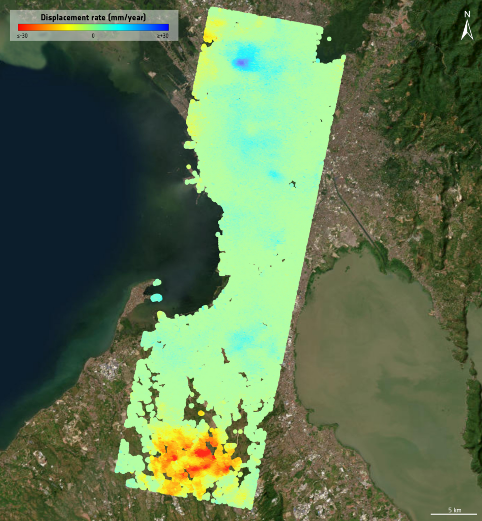
This image shows the Line of Sight (LOS) velocity for an area around Manila. The data have been derived from 57 Copernicus Sentinel-1 images (track 32, descending orbit) spanning the period from 21/01/2020 to 29/12/2022. This image exemplifies the products provided by the Ground Motion service.
Ground Motion Monitoring Service
Ground motion monitoring involves tracking the Earth’s surface movements caused by seismic activity, volcanic eruptions, tectonic shifts, landslides, and human activities such as mining and construction as well as excessive groundwater withdrawal. Within this thematic area, pilot services will be developed to allow for the processing of historical Synthetic Aperture Radar data from the European Union’s Copernicus Sentinel-1 satellite. In the Philippines, located in the Pacific Ring of Fire, ground motion monitoring is essential for disaster risk reduction, particularly for earthquakes and volcanic eruptions. This improved monitoring capability will support local authorities and urban planners in mitigating hazard risks and ensuring public safety.
Land Cover, Forest & Crop Mapping Service
Land cover, forest, and crop mapping are crucial for environmental management, resource planning, and biodiversity conservation. Within this thematic area, pilot services will focus on three types of mapping products: crop layers, tree and forest layers, and other land cover layers, based on processing time series of Synthetic Aperture Radar and optical images acquired by Copernicus Sentinel-1 and Sentinel-2 satellites. The products, as well as the software with which they were developed, will be open source, providing accurate and detailed information on the type of land use as well as on the changes over time in the Philippines. This capability will support local authorities, farmers, and environmental managers in making informed decisions, promoting sustainable land use, improving agricultural productivity, and ensuring effective forest management across the region.
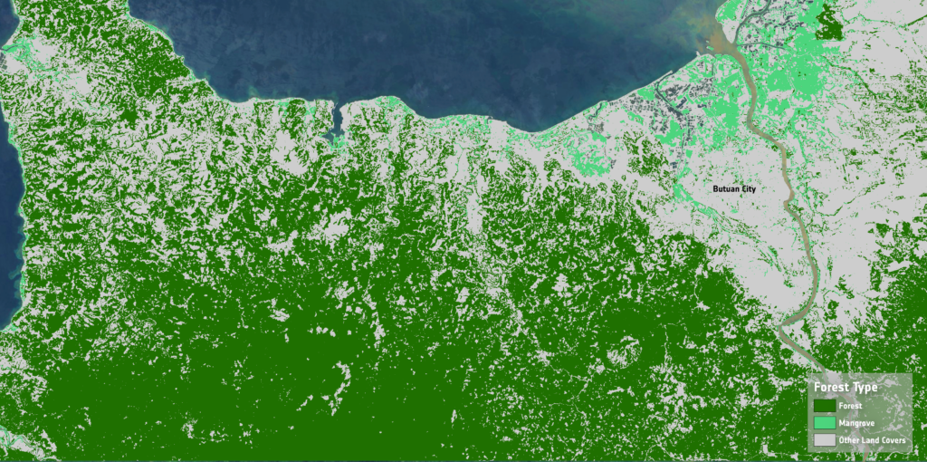
This image shows a sample of the CopPhil Forest Area and Type Product located in the north of the Caraga administrative region in Philippines (Region XIII). The map shows a provisional draft of the forest area and type product including forest, mangrove, other land cover classes. This product has been developed using EO data and artificial intelligence tools.
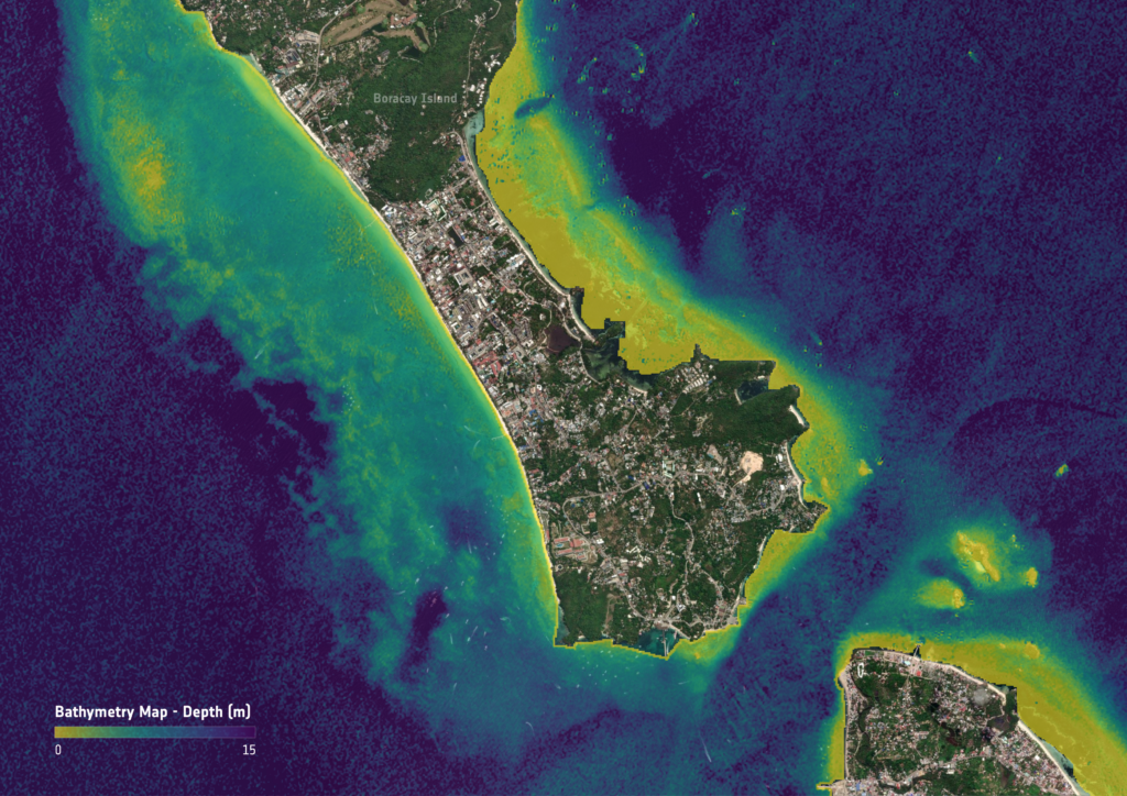
This image shows the Satellite Derived Bathymetry (SDB) retrieved using Copernicus Sentinel-2 satellite data around Boracay Island. SDB provides a depth dimension to the classification in the Benthic Habitat Mapping process.
Coastal Marine Habitat Monitoring Service
Within this thematic area, pilot services will be developed focused on providing detailed and accurate data on coastal habitats. This type of monitoring will provide key information on the status and quality of coastal waters by, for example, mapping different benthic habitat types and monitoring coral bleaching. The products will combine Copernicus Sentinel satellite data and in situ data provided by Filipino stakeholders to confirm that benthic habitats are identified and classified accurately. This stream of services will support local authorities and researchers in understanding and managing these complex ecosystems while contributing to sustainable coastal management, preserving biodiversity, and ensuring the long-term health and resilience of important marine habitats.