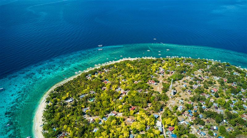
With more than 7,100 islands and one of the world’s longest coastlines, the Philippines boasts a rich array of coastal ecosystems, including coral reefs, mangroves, brackish wetlands, and seagrass beds. These habitats are important both ecologically and economically, sustaining diverse marine life and providing livelihoods for nearly 60% of the population. However, climate change is intensifying many of the country’s most pressing challenges, such as rapid coastal development, overfishing, destructive fishing practices, pollution, ocean acidification, rising sea temperatures, and sea-level rise.
The monitoring of benthic habitats, or those found at the bottom of a body of water, is essential for addressing these challenges, as it enables assessments of the health of marine and freshwater ecosystems. By tracking changes in benthic environments, scientists can detect early signs of ecosystem degradation caused by a changing climate or human activities. These habitats serve as indicators of water quality, carbon sequestration, and biodiversity, making their preservation vital for supporting the lives and economies which depend on them. Additionally, monitoring provides valuable data for policymakers and conservationists, enabling informed decision-making to mitigate environmental threats and promote sustainable resource management.
This article explores how Copernicus data and the CopPhil Benthic Habitat Monitoring Pilot Service can be leveraged to monitor these habitats in the Philippines, thereby supporting the country in protecting these key areas.

Copernicus for Benthic Habitat Monitoring
Benthic data, such as bathymetry and habitat type, are collected through expensive and time-consuming field campaigns. While effective, these surveys are inherently limited in scope and frequency, can only be conducted locally, require significant time and resources, and are subject to environmental and seasonal variations which may affect the consistency of the data. Furthermore, due to logistical constraints, field data collection is not updated regularly, leading to potential gaps in monitoring benthic ecosystems.
Copernicus, the Earth Observation component of the European Union Space Programme, delivers free and open data on coastal areas around the world, providing an alternative to other benthic data collection methods. The integration of optical Copernicus Sentinel satellite data allows for large-scale assessments, enabling simultaneous processing of data over the entire Philippines under the same weather conditions in one comprehensive analysis. With its mission revisit time of up to five days, Copernicus Sentinel-derived data can be regularly updated to produce seasonal and yearly maps. This capability significantly improves the temporal resolution of benthic ecosystem monitoring, providing a more consistent and up-to-date representation of these fragile ecosystems and enabling the continuous monitoring of the Philippines’ coastal waters.
How does CopPhil support benthic monitoring?
As part of its activities, CopPhil is developing a Benthic Habitat Pilot Service to support the Philippines in responding to environmental challenges by providing free and open satellite data on coastal waters and ecosystems. The service helps researchers and authorities to overcome the limitations of traditional data collection and better ensure that benthic habitat assessments remain comprehensive, consistent, and up to date. It leverages an Earth Observation-derived empirical bathymetry module to produce a bathymetric map for each available satellite image, complementing the currently available maps derived from in-situ measurements.
The new maps produced with Copernicus data will enable a more accurate and detailed analysis of the impacts of storms on the seabed and on seasonal changes. The combination of Copernicus satellite data with locally collected field measurements therefore boosts the accuracy of data and deepens understanding of benthic environments by providing continuous monitoring between field acquisitions. The ability to consistently track changes over time is crucial for managing and conserving fragile benthic ecosystems and supporting informed decision-making and sustainable coastal management efforts.
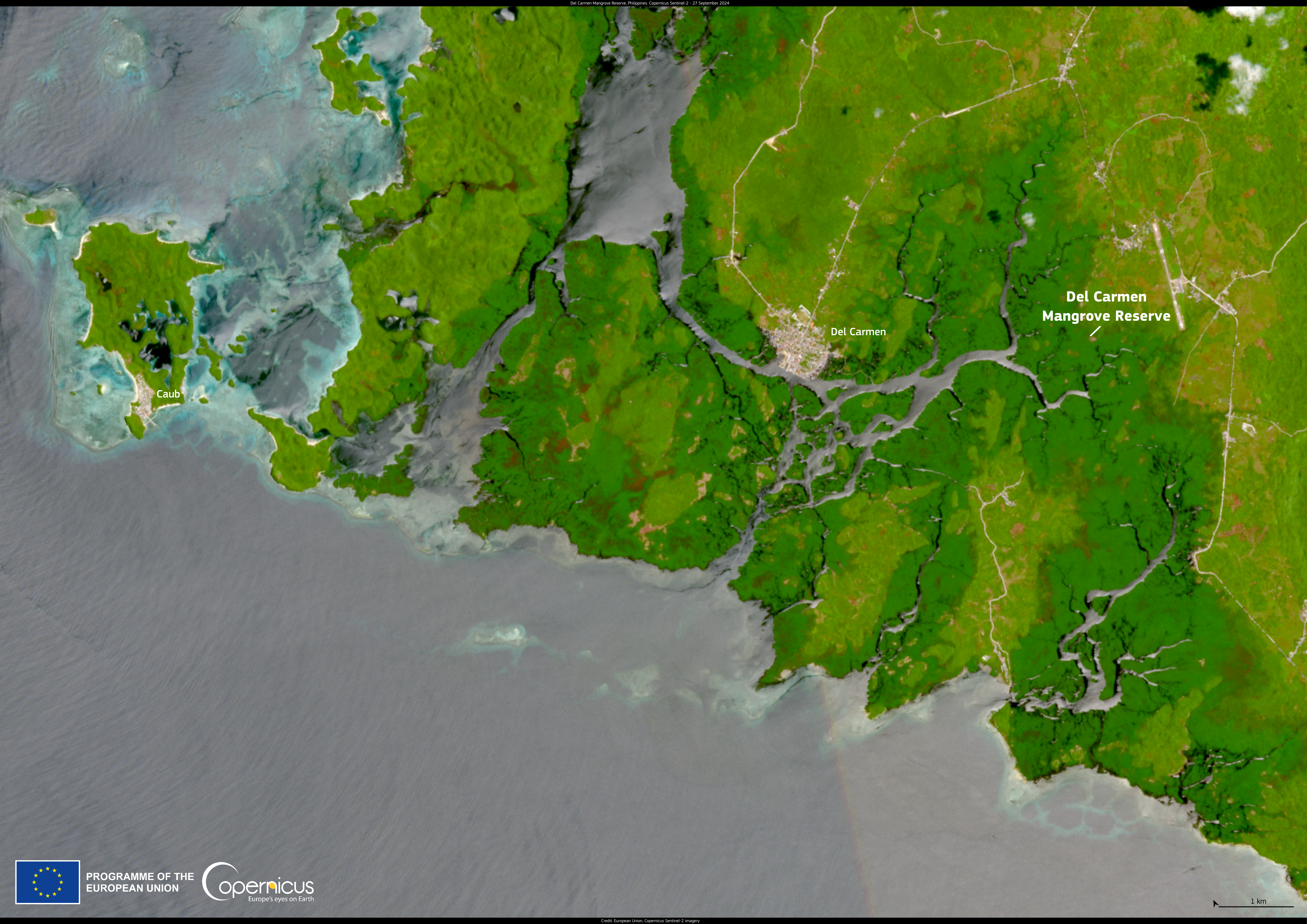
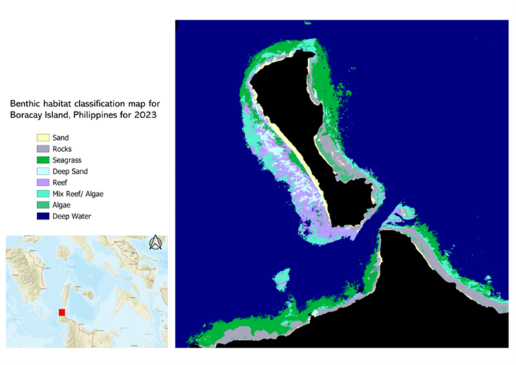
One example of a product which will be produced by the service is the benthic habitat classification map, such as the one below featuring Boracay Island. This product will provide information on the identification and localisation of different habitat types. The maps are created using a system called IOTA2, which combines several machine learning and deep learning methods. It integrates multiple Copernicus Sentinel-2 satellite images taken at different times of the year to show seasonal changes in habitats. Local stakeholders also provide input in the form of on-the-ground information used to label and identify different types of land cover. These products will be produced to focus on the relevant benthic habitat types for each Area of Interest and specific stakeholder needs. The products will inform decisions by providing insights on the evolution of local ecosystems and the impacts of climate change.
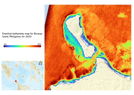
Another product of the service is the empirical bathymetry map, an example of which can be found below, also showing Boracay Island. These products leverage Copernicus Sentinel-2 images and in situ data to derive bathymetry across large areas, especially those in which traditional surveys are difficult to conduct. The maps will be used by institutions in the Philippines to monitor changes in shallow environments through processes such as erosion, sediment redistribution, and more.
The Benthic Habitat Monitoring pilot service – as well as two other thematic pilot services on Ground Motion Monitoring and Land Cover, Forest & Crop Mapping – is the focus of a series of training courses delivered by CopPhil. These courses foster knowledge and skill transfer related to the use of Copernicus data for the specific needs of Filipino institutions. The training series follows a three-part training approach, including a theoretical, practical, and application phase, to ensure that participants both understand the foundations of Earth Observation technologies and are able to apply them effectively.
Through these activities, CopPhil is empowering the Philippines in leveraging Earth Observation data for more sustainable coastal environments and resource management.
Stay up to date on the latest updates and upcoming opportunities from CopPhil by following us on Facebook and on LinkedIn, where we publish a monthly newsletter!
Background Information
As a flagship and unique programme of the EU’s Global Gateway strategy, CopPhil is designed to harness digital resources and space technology for sustainable development and to support innovations in research and business in close cooperation with government partners.
CopPhil is managed by the European Union Delegation to the Philippines. It is implemented by the European Space Agency (ESA) in partnership with the Philippine Space Agency (PhilSA) and the Philippine Department of Science and Technology (DOST).
In addition to the development of the Earth Observation pilot services, the activities of CopPhil include the establishment of a Copernicus Data Centre and IT infrastructure as well as awareness-raising and knowledge and skills transfer related to Copernicus data and information.