The Philippines is one of the most vulnerable countries in the world to disasters, including floods, tropical cyclones, droughts, earthquakes, tsunamis, volcanic activity, and landslides. In fact, 60% of its total land area is exposed to multiple hazards, putting 74% of its population at risk to the impacts of disasters. The intensity and frequency of many of these types of hazards are predicted to increase as a result of climate change, with the potential to impact the health and resilience of local communities and ecosystems.
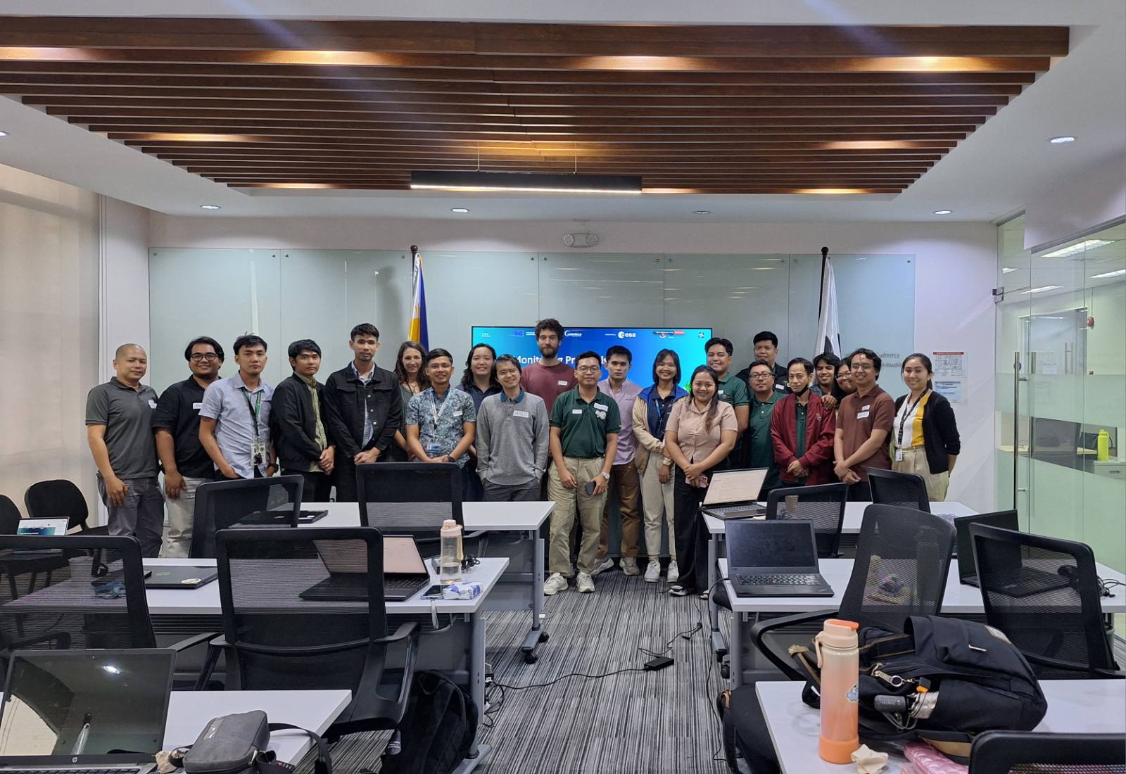
As part of its mission to bring Copernicus data closer to users in the Philippines, the CopPhil Centre is co-developing Copernicus Earth Observation-based pilot services with Philippine stakeholders in three thematic areas:
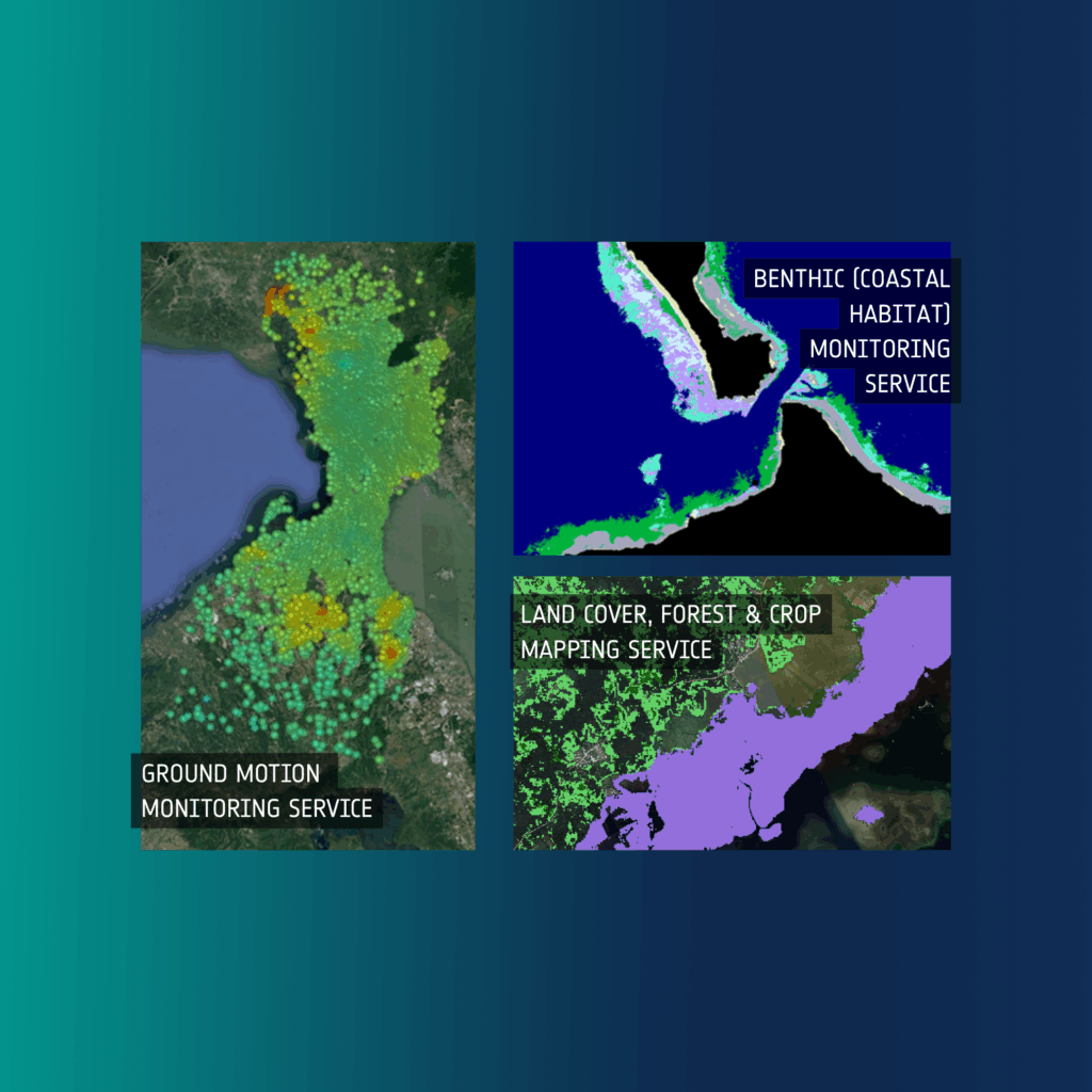
- Ground motion monitoring
- Land cover, forest, and crop mapping
- Coastal marine (benthic) habitat monitoring
The CopPhil pilot services will complement existing regional systems while helping to boost benefits for local communities.
Keep reading to explore each of the pilot services in more detail!
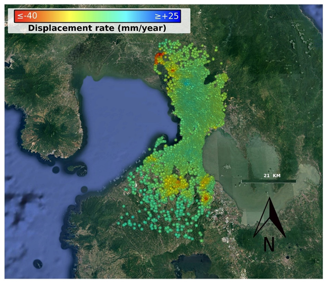
Ground Motion Monitoring Service
The Philippines is situated on the Pacific Ring of Fire, a zone of intense seismic activity characterised by active volcanoes and frequent earthquakes caused by tectonic plate movements. On average, between five and twenty earthquakes occur daily in the Philippines, though most are too minor to be felt. However, when destructive earthquakes do strike, they pose significant risks. The Philippines is also home to 53 active volcanoes, many of which are considered among the most dangerous globally.
The CopPhil Ground Motion Monitoring pilot service works to increase the production of information layers on Earth surface deformation to complement the activities already carried out by institutions in the Philippines. The products are applied in several use cases in the geo-hazard risk domain, including landslides, subsidence, and mining.
This pilot service will support the precise monitoring of seismic events and allow for more accurate early warnings and forecasts regarding ground motion activity, ultimately supporting urban planning and emergency preparedness efforts in areas in the Philippines most at risk to such hazards.
Land Cover, Forest & Crop Mapping Service
The Philippines encompasses diverse ecosystems such as tropical rainforests, grasslands, and pine forests. With a vast array of endemic species, at least 700 of which are considered threatened, the country is a biodiversity hotspot. This natural wealth is a cornerstone of the country’s ecological balance and economic wellbeing. However, these diverse ecosystems and competing demands from urban development, agriculture, and conservation can lead to challenges in land use and resource management.
The CopPhil Land Cover, Forest & Crop Mapping pilot service works to support institutions in the Philippines in leveraging Copernicus open data for these topics. The pilot service builds on existing systems in the country while helping to boost benefits for local communities and ecosystems.
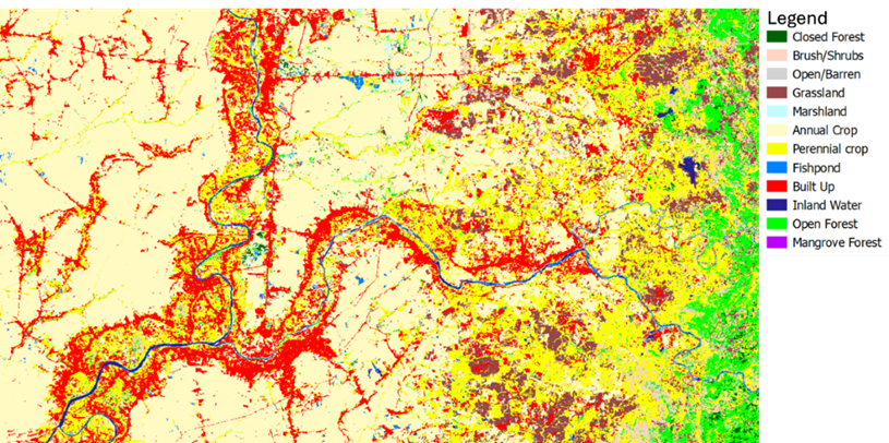
Land Cover
The pilot service dedicated to land cover monitoring will support Filipino authorities, farmers, and environmental managers in promoting sustainable land use.
An example of a product from the land cover service is shown below. This product provides an annual update of the observed (bio)physical cover on the Earth’s surface. The ability to observe the evolution in land use over time is fundamental to sustainable development and environmental conservation. For example, with annual updates to this land use product, stakeholders will be able to consistently track urban expansion and its impact on natural habitats. With CopPhil land cover monitoring products and services, users in the Philippines will be better able to monitor key habitats and preserve biodiversity hotspots.
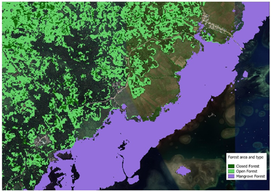
Forest Monitoring
In the Philippines, a total of 1.42 million hectares of tree cover was lost from 2001 to 2022, representing a 7.6% decrease in its total tree cover. Often driven by urban expansion, agricultural conversion, illegal logging, and the demand for timber and fuel, deforestation impacts biodiversity and contributes to greenhouse gas emissions. These activities disrupt ecosystems, lead to soil erosion, alter the water cycle, reduce biodiversity, and exacerbate flooding and droughts.
In this context, the CopPhil pilot service focused on forests works to support the Filipino authorities by developing various products, including:
- Forest Area and Type
- Tree Cover Density
- Forest Cover Change
These products have a range of applications, including guiding sustainable land use planning by helping to identify areas suitable for afforestation (the process of reestablishing a forest area) or agroforestry (integrating trees with crop or pasture systems) while protecting crucial forest habitats. Ultimately, the forest pilot service will support decision-making by tracking changes in forest cover over time.
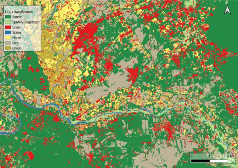
Crop Monitoring
The agricultural sector plays a key role in the Philippines’ economy, contributing around 12% of the country’s gross domestic product (GDP). As of 2023, agricultural land in the country covered around 13.5 million hectares, or around 45% of the total land area. However, intensive cultivation has led to land degradation, affecting forest cover, soil health, and biodiversity.
The CopPhil Crop Monitoring Pilot Service leverages Copernicus satellite data to provide institutions in the Philippines with more comprehensive insights on the state of crop cultivation throughout the country. This information can support the development of sustainable policies and decisions to protect land in the Philippines from degradation.
The service will provide crop extent and crop type maps of major crops in the Philippines, helping institutions to make evidence-based decisions on cultivation practices. Furthermore, the products will enable authorities to analyse and compare real and reported crop cultivation activities to inform the distribution of farm subsidies.
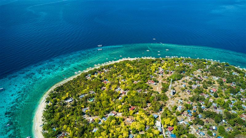
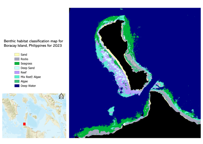
Coastal Marine Habitat (Benthic) Monitoring Service
With over 7,100 islands and one of the longest coastlines in the world, the Philippines is home to diverse coastal resources such as coral reefs, mangroves, brackish wetlands, and seagrasses. These ecosystems are ecologically and commercially essential to the Philippines, supporting important marine life as well as the livelihoods of almost 60% of Filipinos. However, the consequences of a warming climate include the exacerbation of nearly all of the Philippines’ major environmental and disaster risk concerns, including increased coastal development, overfishing and destructive fishing, pollution, ocean acidification, rising sea temperatures, and rising sea levels.
To support the Philippines in responding to these challenges, the CopPhil Benthic Habitat Pilot Service will provide geospatial products such as bathymetry maps and benthic habitat classification maps, which will help authorities and researchers to consistently track changes in the coastal environment over time. With these products, the Filipino authorities will be better equipped to manage coastal resources, preserve biodiversity, and ensure the long-term health of essential marine habitats.
The unique geography and landscape of the Philippines makes it especially vulnerable to the consequences of climate change. Filipino institutions have been employing Earth Observation technologies to help address these challenges and contribute to a more sustainable future. By providing products and information tailored to the needs of the Philippines and developed in close collaboration with local stakeholders, the CopPhil Earth Observation pilot services will support the country in preparing for future hazards and the impacts of climate change. Follow CopPhil on LinkedIn and Facebook to stay informed about the latest developments and news from its pilot services
Background Information
As a flagship and unique programme of the EU’s Global Gateway strategy, CopPhil is designed to harness digital resources and space technology for sustainable development and to support innovations in research and business in close cooperation with government partners.
CopPhil is managed by the European Union Delegation to the Philippines. It is implemented by the European Space Agency (ESA) in partnership with the Philippine Space Agency (PhilSA) and the Philippine Department of Science and Technology (DOST).